-
E-mail
1401548526@qq.com
-
Phone
13371051536
-
Address
209, Building 1, Weifang High tech Zone Optoelectronic Industry Accelerator (Phase I), 155 Guangdian Circuit, Weifang High tech Zone, Shandong Province
Product Categories
- Explosion proof meteorological station
- Slope monitoring system
- Rice planthopper monitoring device
- Rice thrips forecasting instrument
- Negative oxygen ion monitoring system
- Rice blast disease monitoring instrument
- Temperature and humidity recorder
- Pigeon Flying Ability Appraisal Instrument
- Locust real-time monitoring and warning station
- Potato late blight monitoring device
- Pigeon DNA testing equipment
- Rainfall monitoring instrument
Shandong Fengtu IoT Technology Co., Ltd


Slope monitoring radar
NegotiableUpdate on 02/20
- Model
- Nature of the Manufacturer
- Producers
- Product Category
- Place of Origin
Overview
Slope monitoring radar can achieve continuous monitoring of the monitoring area, ensuring real-time and continuous data. At the same time, by comparing and analyzing the scanning results with the preset warning threshold, the radar system can automatically trigger the warning mechanism. When the slope displacement exceeds the threshold, a timely warning signal is issued to enable relevant personnel to take necessary preventive measures and reduce potential safety risks.
Product Details
Slope monitoring radarIt can achieve continuous monitoring of the monitoring area, ensuring real-time and continuous data. At the same time, by comparing and analyzing the scanning results with the preset warning threshold, the radar system can automatically trigger the warning mechanism. When the slope displacement exceeds the threshold, a timely warning signal is issued to enable relevant personnel to take necessary preventive measures and reduce potential safety risks.
1、 System Introduction
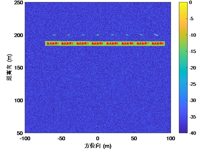
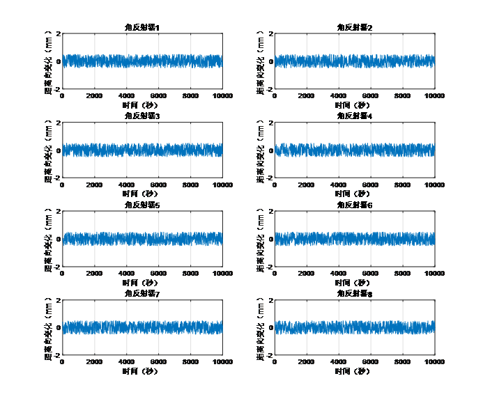
Slope monitoring radarIt is a high-precision, portable microwave interference measurement micro deformation monitoring product based on broadband MIMO array. It uses non-contact method to perform high-precision uninterrupted cyclic measurement on the target body, and accurately measures the displacement changes and displacement speed of the monitored target. It can accurately track slow and small displacements, thus achieving remote monitoring of the monitored target all day, all-weather, non-contact, high-precision, spatiotemporal continuous. It is a new type of high-precision measurement instrument in the industry.
By remotely scanning and monitoring the surface of the monitoring area, high-precision displacement can be obtained throughout the entire area, achieving continuous monitoring of the entire region. And by comparing and analyzing the scanning results with the warning threshold, automatic early warning is provided to achieve the goal of early detection, early warning, ensuring safety, and reducing losses. This product has the characteristics of all-weather, wide range, and high precision, and is suitable for slope deformation monitoring in open-pit mines, water conservancy and hydropower dams, geological landslide disasters, and other scenarios.
2、 Product Usage
Building deformation monitoring
Slope deformation monitoring
Mine deformation monitoring
Excavation deformation monitoring
Dam deformation monitoring
3、 Product Features
Quick deployment: Instrument deployment takes less than 1 minute
Convenient and fast: single person installation operation
Measurement accuracy: 0.1mm
Strong adaptability; All day, all weather
Cost of use: Recycling
Security risk: No need to approach the tested area
4、 Compliant with specifications
CH/T 3020-2018 Technical Specification for Lidar Measurement of Realistic 3D Geographic Information Data
GJB 6692-2009 General Specification for Airborne Synthetic Aperture Radar
5、 Performance parameters
| structural form | MIMO、 Sliding rail type, rotating type |
| Installation method | Support fixed, vehicle mounted and other installation methods |
| operating frequency band | 5.2-6GHz or 24-26GHz |
| monitoring information | Displacement/velocity/acceleration |
| measure distance | ≥5km |
| measurement accuracy | Deformation accuracy ≤ 0.1mm |
| resolution | Resolution ≥ 1 ㎡ at 1km |
| monitoring scope | Horizontal 100 °, vertical 40 ° |
| Monitoring area | Depending on the monitoring distance |
| size | Length x Width x Height 140cm x 15cm x 35cm |
| weight | Less than 10kG |
| Power supply requirements | Support power supply modes such as mains electricity, generators, solar energy, etc |
| monitoring cycle | ≤1s |
| power consumption | 30W |
| Operating Temperature | -40℃~60℃ |
| Protection level | IP67 |
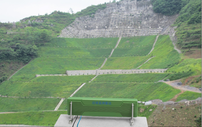
6、 Application Display