-
E-mail
wangyingying@yunjingtianhe.com
-
Phone
13276363312
-
Address
Room 206, Building 1, Weifang High tech Zone Optoelectronic Industry Accelerator (Phase I), No. 155 Optical Circuit, Weifang High tech Zone, Shandong Province
Product Categories
Shandong Tianhe Environmental Technology Co., Ltd


Soil erosion monitoring instrument
NegotiableUpdate on 02/12
- Model
- Nature of the Manufacturer
- Producers
- Product Category
- Place of Origin
Overview
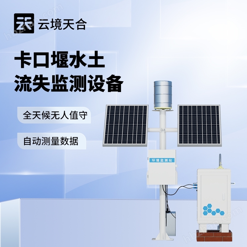
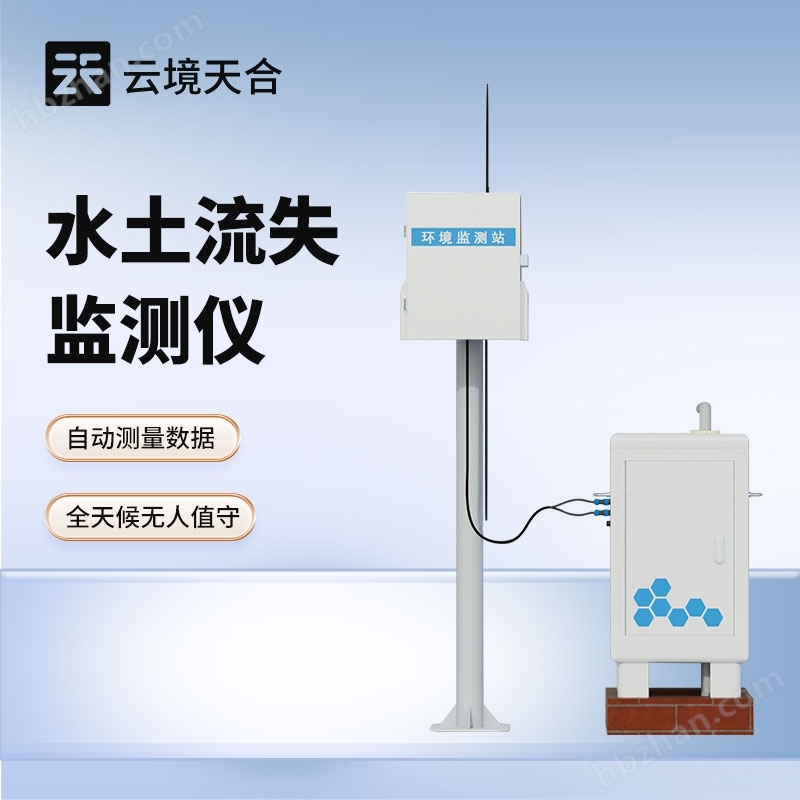
Soil erosion monitoring instrument is a precision equipment specifically used for monitoring and evaluating the soil erosion status of land. It integrates multiple sensors and advanced technological means to monitor key parameters such as soil erosion degree, water flow velocity, and sediment content in real time and accurately, providing key data support for water and soil conservation, ecological restoration, and sustainable agricultural development.
Product Details
Soil erosion monitoring instrumentIt is a precision instrument and equipment specifically used for monitoring and evaluating the status of soil erosion on land. It integrates multiple sensors and advanced technological means to monitor key parameters such as soil erosion degree, water flow velocity, and sediment content in real time and accurately, providing key data support for soil and water conservation, ecological restoration, and sustainable agricultural development.

1、 Product Introduction
In the monitoring of soil erosion in runoff fields and small watersheds, traditional manual measurement of flow and sediment data has the problems of large workload and low efficiency, as well as high labor costs and large data errors. The automatic monitoring system for soil erosion has undergone years of technological breakthroughs and extensive field experiments, successfully revolutionizing the traditional manual monitoring mode.
Soil erosion monitoring instrumentComposed of a data acquisition main control machine, sediment concentration measurement sensor, and open channel flow sensor. Among them, the open channel flow sensor component can automatically measure the runoff flow and accurately calculate the total runoff and instantaneous runoff data at different time periods through the controller; The sediment concentration measurement sensor collects real-time sediment concentration data based on the characteristics of runoff changes at sediment measurement ports with vertical distribution of runoff. The collaborative operation of various sensors and the collected data have critical value for soil erosion analysis.
The system uploads real-time sediment content and runoff collected by various sensors to the cloud platform, making it easy for users to access, analyze, and manage data anytime and anywhere, providing scientific and accurate data support for soil and water conservation decisions.
Workflow of sediment content sensor: Surface water enters an open channel or Bacher trough through a water diversion channel and passes through an open channel flowmeter to obtain instantaneous runoff data, and calculates the total runoff per unit time. The surface water is collected by a water diversion pipe and sent to the main water tank. When the surface water capacity of the main water tank is sufficient for detection, the system starts and sends the surface water to be measured to the sample bin for detection. The sensor sends the collected data to the processor for processing to obtain sediment content. After obtaining the data, the sensor discharges the internal sample through the drainage pipe to prepare for the next sampling. The processor outputs to external devices through 485.
2、 Product Features
1. 24/7 unmanned operation, automatic measurement of runoff volume, sediment concentration, and total runoff volume.
2. Electricity supply from the city, unmanned 24/7, automatic data measurement.
3. It has the function of online real-time monitoring, displaying the dynamic process and curves of various measurement parameters, and downloading historical data on computer software.
4. The sampling frequency and clock can be freely set and calibrated on the data management main control machine on site.
5. Good stability, independently developed sensor with high accuracy, strong stability, and strong resistance to environmental interference.
3、 Technical indicators
| Runoff flow measurement | |
| resolution | 0.1m³/h |
| measurement accuracy | 1% to 5% of the measuring range (depending on the accuracy of the weir) |
| blind spot | 30~50cm |
| Measurement of sediment concentration | |
| Measuring principle | Weighing method |
| sampling frequency | 1 to 99 minutes |
| measurement range | 0~500kg/m3; |
| resolution | 0.01kg/m3 |
| measurement accuracy | <10% |
| General indicators | |
| contact method | RS485 |
| working power supply | DC12V |
| Equipment power | <15W |
| working environment | Temperature: 0 (non freezing)~50 ℃; Humidity:<95% (no condensation) |
| working life | >1 year |
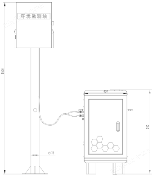
4、 Product size and working diagram

5、 Maintenance and upkeep
Please loosen the transport fixing rod before initial use, otherwise the equipment will not work properly.
When using it for the first time or for a long time without reusing it, please perform water calibration and zero calibration again.
Regularly check the water storage tank. If there is a large amount of sludge deposition or debris, please remove it. Remove the drainage valve and rinse it clean.
Regularly check the drainage valve, sample bucket inlet valve, sample bucket drain valve, and whether the water flow is unobstructed. If the water flow is weak or blocked, the control line on the drain valve can be removed and the drain valve can be disassembled for cleaning, and then reinstalled.
Keep the interior of the device clean, prohibit the accumulation of items in the weighing section, and prohibit the placement of items under the sample bucket.
When the temperature in the area where the equipment is located drops below zero, please drain the water inside the equipment and place it in a place where it freezes and damages the equipment.
When the sensor has been used for a long time and measurement errors occur, calibration and correction can be carried out by cooperating with the instrument. If the above methods of maintenance and upkeep still cannot calibrate and measure the sensor, it indicates that the sensor has been damaged.
6、 Introduction to Cloud Platform
The IoT cloud platform is a data receiving, processing, and analysis platform based on IoT communication technology. It supports MQTT device communication protocol, HJ212-2017 and HJ212-2005 environmental protocols, TCP/IP short link data forwarding, HTTP protocol data forwarding, real-time and historical data query and analysis, waveform display of time series data, data aggregation, real-time video access, and device maps.